Not ones to squander the early morning hours when we were in the desert in May, we headed out early to drive the Apache Trail, which starts at Apache Junction, near Phoenix.

We had a vague memory of having driven this road sometime back in the early 80s when we were traveling with our three boys in our VW camper van. Maybe we had thoughts of finding that illusive gold mine in the Superstition Mountains. But this visit was purely to drive part of the trail and to take a hike on one of the trails at the Lost Dutchman State Park. I called ahead to make sure we didn't need to book. At the entrance gate the ranger asked if were were there to hike because he told us many think they can come and drive through the park. The road is short and leads only to the parking lots for the hiking trails. There was one car ahead of us.

The park is located at the foot of the Superstition Mountains and takes its name from the fabled gold mine no one has ever been able to find. We chose the Treasure Loop, Tr. No 56. It was of moderate length , 2.4miles, climbing up to the mountainous out-cropping seen behind David in the first photo. The trail is quite wide to begin although narrows higher up. The surface is stony so eyes down much of the time but frequent stops to take in the views.

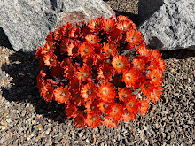
This is the Sonoran desert and the familiar cholla, prickly pear and ocotillo fit perfectly into the arid landscape. On the lower level we encountered lot of cholla with their hanging fruits which I had never encountered before.

They are called chainfruit cholla, Cylindropuntia fulgida, for their grape-like clusters of fruits.


Other members of the cholla family include teddy bear and pencil. All chollas will readily cling to your clothing or skin if you venture too close to them. They have a reputation for jumping at you but this is false. However, you may not even be aware that you have brushed against one until you find one clinging to your skin. I speak from experience!

As the trail continued on up we speculated as to where the trail would start to make the return loop. Opportunities came and went until we found ourselves right at the base of the mountain. I looked up at a cave wondering if some kind of animal might be taking shelter in there and looking down on us. Mountain lion maybe? As we reached the high point and started to go down I began to wish that I had brought my hiking poles. When will the time come that we take them on every hike? We always carried and used them when hiking in Idaho but recently we have had several occasions to wish we had them with us. They really aid in both going up and going down a steep rocky trail. My replaced hip is fine but the other hip I was supposed to have replaced 2 years ago has difficulty and the last thing I want to do is jar it or fall and break it-or break anything for that matter. And just as we began to go down my phone rang and we had a Facetime with our son in Dubai! Better reception up there than at our house! There was pleasant breeze throughout the hike but back on the desert floor things were hotting up and it was good to get back in the car with AC.
We left the park and continued on the Apache trail. Stretching 47 miles from Apache Junction to Globe Originally used by the Apache Indians as a migration route, who took advantage of the trails created by the Salado Indians who lived there in 900 AD, to raid villages along the Salt river. Later it became a stagecoach route and was used as a supply route for the building of the Roosevelt dam on the Salt river from 1906-1911. The Apache who worked on the road lived in brutal conditions during the building during which time the road was closed. On completion was opened as a tourist route.
The road winds through some spectacular scenery which we enjoyed from our car as there are few places to stop on the narrow road. At Canyon lake we went down to the marina to look for somewhere to eat. We were fortunate to find one with an outdoor deck and we opted to stop for lunch and a cold beer.

We decided not to continue further along the road. There will be other opportunities when we are can explore further along the road and I was anxious to find a stop on the road where I could get a closer look at the unusual yellow/green rocks. There are few places to stop and none it the best spots but I was able to walk up closer to some of the rocks to get a close-up look. As I suspected it was lichen.

Our final stop fo the day was at the rather commercial mining town. I'll bet we took the boys there in the 80s. A quick walk up the main street. No need to go in the shops or bars. Then we headed back to Ahwatukee where our son and family live.


4 comments:
You and your husband are intrepid! I'm glad your're able to get back to traveling a bit.
Interesting history to the park. What is it like hiking in the Sonoran Desert? Always think of deserts asbeing too hot to hike in but have never actually been in one Obviously much more there than sand. thanks for taking us along.
Wonderful photos Jenny. It's been too long since I've visited the desert.
Enjoyed going along with you two on your desert trek. Hope your hip didn't get too upset.
Post a Comment